XGRIDS Unveils Lixel L3 at INTERGEO 2026, Setting a New Benchmark for Spatial Capture with Validated 5 mm Accuracy
MUNICH, Sept. 15, 2026
Press Release Disclaimer: This is a press release distributed through the XPR Media network. It has not been independently verified by our newsroom.

XGRIDS Unveils Lixel L3 at INTERGEO 2026, Setting a New Benchmark for Spatial Capture with Validated 5 mm Accuracy
PR Newswire
MUNICH, Sept. 15, 2026
MUNICH, Sept. 15, 2026 /PRNewswire/ — XGRIDS, the spatial intelligence company, today introduced Lixel L3, its flagship high-accuracy spatial scanner with validated 5 mm relative accuracy, demonstrated against measured ground truth in a documented test.
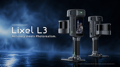
The L3 fuses a high-accuracy LiDAR, a true-color vision system, an integrated RTK, and a built-in display into one system, uniting geometry, color, positioning, and delivery in a single capture workflow. Captured data can be processed locally and turned into 3D outputs for downstream applications, with L3 typically covering around 100 square meters in 10 minutes for high-accuracy data and photorealistic 3D models, making it well suited to large, complex sites.
Verified 5 mm Accuracy
Lixel L3 achieves 5 mm relative accuracy and approximately 2.5 cm real-time absolute accuracy. Its integrated SLAM system maintains stability throughout the scan, while real-time vision-aided localization and leveling optimization help control accumulated drift during longer scanning sessions.
“5 mm relative accuracy only matters if it holds up in the field and the data can go straight into BIM,” said Sunny Liao, Director of International Sales and Marketing at XGRIDS. “Customers can capture, process and export locally and the data is ready for the workflow.”
Photorealistic Spatial Capture
L3 combines high-accuracy spatial sensing with a 1/1.3-inch CMOS 4K HDR imaging system, capturing color and surface detail alongside precise geometry. From a single scan, L3 produces true-color point cloud, detailed mesh and photorealistic 3DGS models. As 3DGS transitions into mainstream production—highlighted by Autodesk introducing support for 3DGS in 3ds Max and Trimble integrating it into SketchUp—XGRIDS’ proprietary LCC2 format is among the early 3DGS formats supported by established software platforms, bringing photorealistic physical assets directly into AEC, film and entertainment, and virtual production workflows.
Built for Field Crews
Designed for fieldwork, L3 features a 4.3-inch display for scan status, trajectory and coverage. Map fusion aligns multiple scans without preset control points, while privacy protection can blur faces and license plates.
XGRIDS Lixel L3 brings next-level accuracy and photorealism together, elevating the standard for how physical environments are captured, reconstructed, and put to work. As 3DGS moves into mainstream production and spatial data becomes a foundational layer for digital experiences, XGRIDS is building the infrastructure that connects physical reality with the digital world.
 View original content to download multimedia:https://www.prnewswire.com/news-releases/xgrids-unveils-lixel-l3-at-intergeo-2026-setting-a-new-benchmark-for-spatial-capture-with-validated-5-mm-accuracy-302878789.html
SOURCE XGRIDS